1
$\begingroup$

This is a followup to this question of mine. From reading the wiki article, I get that:

Radio waves at MF wavelengths propagate via ground waves and reflection from the ionosphere ( called skywaves). Ground waves follow the contour of the Earth. At these wavelengths they can bend (diffract) over hills, and travel beyond the visual horizon, although they may be blocked by mountain ranges.

Apart from not locating the source of transmissions right by a mountain range, is there any way in which elevation does come into consideration when placing a transmitter, radio tower, etc.?

I realize this is somewhat of a vague question, but since my dataset doesn't have good data on conditions in the ionosphere, I'm left trying to consider other factors in my (extremely) rough estimates, as in my other questions.
$\endgroup$

1 Answer 1

4
$\begingroup$

Groundwave field intensities in the MW broadcast band depend almost entirely on radiated power, frequency, and Earth conductivity.

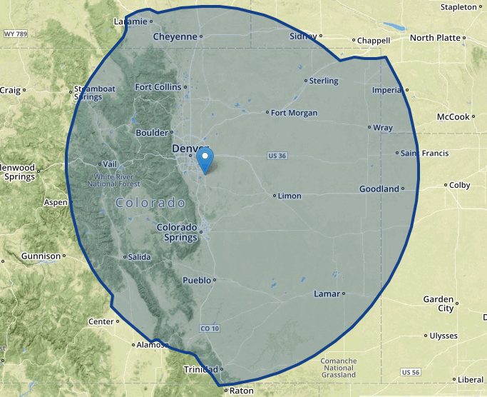
Below is a map of the 0.5 mV/m groundwave contour of radio station KOA, Denver (50 kW transmitter, 850 kHz, omnidirectional transmit antenna). Their transmit site is close to the eastern edge of the Rocky Mountains.

The average propagation path loss is higher in the directions of the mountain range, but that is due to the lower relative conductivity of Earth in the Rockies, not because they are "blocking" the signal.

Granted, there can be valleys/canyons within mountainous terrain areas where MW signals are seriously reduced by blockages. The coverage map below shows the general case.

enter image description here

$\endgroup$
4
  • $\begingroup$ Do you know of any detailed datasets (like latitude/longitude/value) for the conductivity of the Earth? I think that would be useful for what I'm getting at $\endgroup$
    – Michael A
    Commented Oct 16, 2018 at 2:26
  • 1
    $\begingroup$ AFAIK, no such digital dataset is publically available as a single, executable application. Groundwave coverage contours for AM broadcast stations in the mainland U.S. such as that above use Earth conductivities shown on the FCC "M3" map — which map is available at fcc.gov/media/radio/m3-ground-conductivity-map. The software generating those coverage maps includes a digitized form of the M3 map including the geographic boundaries for those conductivity zones, but access to that data set requires use of that specific software. $\endgroup$ Commented Oct 16, 2018 at 12:23
  • $\begingroup$ Thanks for the answer. 0.5 mV/m is the FCC's standard threshold for electric field strength, right? To determine (approximately) which stations "overlap" for the purposes of assigning coverage? $\endgroup$
    – Michael A
    Commented Dec 9, 2018 at 21:02
  • $\begingroup$ Michael A: Below is a link to a clip from Part 73 of Title 47 of the U.S. Code of Federal Regulations, showing the current FCC e-field protection requirements for AM broadcast stations in the U.S. i.postimg.cc/g05FqfJ2/… $\endgroup$ Commented Dec 18, 2018 at 12:45

You must log in to answer this question.

Not the answer you're looking for? Browse other questions tagged .